42/108

 Download Photo
)
)
)
)
)
)
)


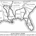
Map of 1515, showing what some geographers then supposed North America to be. This is one of the earliest maps on which the name America occurs. It will be notices that at that time it was confined to South America.
- Author
- The Leading Facts of American History
By David Henry Montgomery
Published in 1890
Available from books.google.com - Posted on
- Thursday 23 July 2020
- Dimensions
- 1242*908
- Tags
- Century:16th , Discovery, Maps, Place:America
- Visits
- 1617
- Downloads
- 63