441/873
 and ended with the late Wisconsinan (f—the youngest). Diagram “d” shows the major stream development during the time between the Illinoian and the earliest Wisconsinan glaciers. The heavy lines on the diagrams indicate major stream valleys that were present during these times.
a. Inferred limit of NEBRASKAN glaciation
b. Inferred limit of KANSAN glaciation
c. ILLINOIAN glacial advance
d. SANGAMONIAN major drainage
e. Maximum WISCONSINAN glacial advance
f. Late WISCONSINAN Valparaiso front and Kankakee Flood")
 Download Photo
)
)
)
)
)
)
)


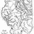
Extent of the main glacial advances which began with the Nebraskan (a—the oldest) and ended with the late Wisconsinan (f—the youngest). Diagram “d” shows the major stream development during the time between the Illinoian and the earliest Wisconsinan glaciers. The heavy lines on the diagrams indicate major stream valleys that were present during these times.
a. Inferred limit of NEBRASKAN glaciation
b. Inferred limit of KANSAN glaciation
c. ILLINOIAN glacial advance
d. SANGAMONIAN major drainage
e. Maximum WISCONSINAN glacial advance
f. Late WISCONSINAN Valparaiso front and Kankakee Flood
- Author
- Inside Illinois: Mineral Resources
Educational Series 9
Author: Anonymous Available from gutenberg.org - Posted on
- Wednesday 22 September 2021
- Dimensions
- 1000*1155
- Tags
- Maps, Place:America, Prehistoric
- Albums
- Visits
- 1038
- Downloads
- 42