2/3
Home / Albums / Search results /

Map Showing Routes of Cartier, Champlain, and La Salle

Map Showing Routes of Cartier, Champlain, and La Salle.jpg Captain John Smith’s Map of New EnglandThumbnailsMap showing the first settlements made on the Eastern coast of North AmericaCaptain John Smith’s Map of New EnglandThumbnailsMap showing the first settlements made on the Eastern coast of North AmericaCaptain John Smith’s Map of New EnglandThumbnailsMap showing the first settlements made on the Eastern coast of North AmericaCaptain John Smith’s Map of New EnglandThumbnailsMap showing the first settlements made on the Eastern coast of North AmericaCaptain John Smith’s Map of New EnglandThumbnailsMap showing the first settlements made on the Eastern coast of North AmericaCaptain John Smith’s Map of New EnglandThumbnailsMap showing the first settlements made on the Eastern coast of North AmericaCaptain John Smith’s Map of New EnglandThumbnailsMap showing the first settlements made on the Eastern coast of North America
Google+ Twitter Facebook Tumblr

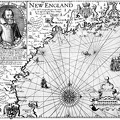
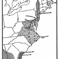
Map Showing Routes of Cartier, Champlain, and La Salle, also French and English Possessions at the Time of the Last French War.

Author
Project Gutenberg's American Leaders and Heroes, by Wilbur Fisk Gordy Published 1907
Dimensions
1376*860
Albums
Visits
2164
Downloads
78