3/3
Home / Albums / Tags Century:17th + Place:America + Maps /
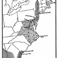
Map Showing Routes of Cartier, Champlain, and La Salle

 Download Photo


Map Showing Routes of Cartier, Champlain, and La Salle, also French and English Possessions at the Time of the Last French War.
)
)
)
)
)
)
)
- Author
- Project Gutenberg's American Leaders and Heroes, by Wilbur Fisk Gordy Published 1907
- Posted on
- Tuesday 17 March 2020
- Dimensions
- 1376*860
- Albums
- Visits
- 1819
- Downloads
- 59