68/70
Accueil / Albums / Albums Timelinesx + Prehistoricx /

World as known to the Ancients

World as known to the Ancients.jpg Time-chart A.D. 1220-A.D. 1920MiniaturesImperial Federation-Map of the world showing the extent of the British Empire in 1886Time-chart A.D. 1220-A.D. 1920MiniaturesImperial Federation-Map of the world showing the extent of the British Empire in 1886Time-chart A.D. 1220-A.D. 1920MiniaturesImperial Federation-Map of the world showing the extent of the British Empire in 1886Time-chart A.D. 1220-A.D. 1920MiniaturesImperial Federation-Map of the world showing the extent of the British Empire in 1886Time-chart A.D. 1220-A.D. 1920MiniaturesImperial Federation-Map of the world showing the extent of the British Empire in 1886Time-chart A.D. 1220-A.D. 1920MiniaturesImperial Federation-Map of the world showing the extent of the British Empire in 1886Time-chart A.D. 1220-A.D. 1920MiniaturesImperial Federation-Map of the world showing the extent of the British Empire in 1886
Google+ Twitter Facebook Tumblr

Map of the World as known to the Ancients

Auteur
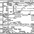
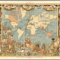
Celebrated Travels and Travellers, Part I. The Exploration of the World by Jules Verne
Available from gutenberg.org
Dimensions
1261*782
Mots-clés
Maps
Albums
Visites
1538
Téléchargements
101