


« 2020
2022 »
January
February
March
April
May
June
July
August
September
October
November
December
All

 The fire horses stand ready in their stalls, and at the sound of the alarm gong the stall chains are...") Horses in the fire station
Horses in the fire station
The fire horses stand ready in their stalls, and at the sound of the alarm gong the stall chains are let down and each horse goes quickly to his place at the engine, and the big iron collars are clamped around their necks and off they go to the fire, with the engine, at break-neck speed.") The Alarm
The Alarm The Automobile Fire Engine can go to the fires very swiftly. Many times the saving of a few minutes ...") The Automobile Fire Engine
The Automobile Fire Engine
The Automobile Fire Engine can go to the fires very swiftly. Many times the saving of a few minutes by the firemen in reaching a fire means stopping the blaze before it becomes too great. The brave fireman rescues many people who are caught in burning buildings, in this way risking his l...") The brave fireman
The brave fireman
The brave fireman rescues many people who are caught in burning buildings, in this way risking his life that others may be saved from the smoke and flames. Many people owe their lives to the bravery of the firemen. The Hoze nozzle has been taken up to the roof of a building next the one afire and the firemen are s...") The Hoze nozzle
The Hoze nozzle
The Hoze nozzle has been taken up to the roof of a building next the one afire and the firemen are sending the water into the upper floors of the burning building. The hose nozzle is very difficult for the firemen to hold. The Fire Alarm is sounded by a big gong in the station from street alarm boxes near where the fire o...") The Fire Alarm
The Fire Alarm
The Fire Alarm is sounded by a big gong in the station from street alarm boxes near where the fire occurs. The firemen know these alarm stations so well that they seldom look for the address, but dash off quickly to the correct place. The Fireman's dog goes to every fire, running beside the horses, barking a command to hurry. He gets...") The Fireman's dog
The Fireman's dog
The Fireman's dog goes to every fire, running beside the horses, barking a command to hurry. He gets to the fire hydrant first and sits there panting until the Firemen come up to attach the hose and turn on the water. The Round House is the place where the railroad engines are kept when they are not working. The engi...") The Round House
The Round House
The Round House is the place where the railroad engines are kept when they are not working. The engines are turned around on a big turn table so each can be run on the different tracks which all lead to the turn-table in the centre. The water tank is seen frequently along the route of the railroads and plenty of water must be taken...") The water tank
The water tank
The water tank is seen frequently along the route of the railroads and plenty of water must be taken on and carried in the engine tender to make steam which is the power used to drive the big engines.") The flag Major Anderson carried with him from Fort Sumter
The flag Major Anderson carried with him from Fort Sumter") Latest Fashions, September 1841
Latest Fashions, September 1841") Apples
Apples") The Residence of Abraham Lincoln
The Residence of Abraham Lincoln President-Elect") Abraham Lincoln
Abraham Lincoln
President-Elect Physiography is the study of the creation and gradual change of land surface forms (the landscape). ...") Physiographic provinces of Illinois
Physiographic provinces of Illinois
Physiography is the study of the creation and gradual change of land surface forms (the landscape). Thus, the land surface as we see it today in each of the physiographic provinces has had a particular history of development. Driftless Area Wisconsinan Moraines Illinoian Till Plain Mississippi River Wabash River Shawnee Hills Ohio River Crust (6-30 miles)
Mantle (1800 miles)
Outer core (1400 miles)
Inner core (750 miles)
The core...") The earth with a segment removed to show supposed internal zones
The earth with a segment removed to show supposed internal zones
Crust (6-30 miles) Mantle (1800 miles) Outer core (1400 miles) Inner core (750 miles) The core is the innermost zone of the earth. It is mainly iron with some nickel and cobalt. The inner core probably is solid, but the outer core may consist of the same elements in a molten form. The core is the most dense (heaviest) of the three zones. Extent of the main glacial advances which began with the Nebraskan (a—the oldest) and ended with t...") Extent of the main glacial advances
Extent of the main glacial advances
Extent of the main glacial advances which began with the Nebraskan (a—the oldest) and ended with the late Wisconsinan (f—the youngest). Diagram “d” shows the major stream development during the time between the Illinoian and the earliest Wisconsinan glaciers. The heavy lines on the diagrams indicate major stream valleys that were present during these times. a. Inferred limit of NEBRASKAN glaciation b. Inferred limit of KANSAN glaciation c. ILLINOIAN glacial advance d. SANGAMONIAN major drainage e. Maximum WISCONSINAN glacial advance f. Late WISCONSINAN Valparaiso front and Kankakee Flood In Canada vast thicknesses of snow and ice accumulated until the weight of the ice finally caused it...") Limits of ice age glaciers
Limits of ice age glaciers
In Canada vast thicknesses of snow and ice accumulated until the weight of the ice finally caused it to flow slowly outward, mainly to the south. Rocks and surface materials of all types were picked up and carried by the glaciers for great distances before being deposited. Pieces of granite, quartzite, and native copper among the many local rocks and minerals are found in glacial deposits and indicate that at least part of these deposits came from the Great Lakes Region. The materials deposited range from clay-size minerals to large boulders. Scattered mammoth and mastodon remains have been found in glacial deposits at various localities in ...") Woolly mammoth
Woolly mammoth
Scattered mammoth and mastodon remains have been found in glacial deposits at various localities in the state. Peat, which is an accumulation of partially decomposed plant materials, has been found, especially in the northern part of the state. It is marketed as an organic soil conditioner. Coal is a combustible rock that was formed by the accumulation and partial decay of vegetation. When...") Reconstruction of coal-forming swamp
Reconstruction of coal-forming swamp
Coal is a combustible rock that was formed by the accumulation and partial decay of vegetation. When coal was forming millions of years ago, most of the state was a low coastal plain bordered on the west and southwest by a shallow sea. A large variety of plants grew in great swamps which covered this coastal plain. When the plants died, they accumulated in the swamps to form thick masses of peat that were eventually covered by shallow seas and buried beneath mud and sand. Periodically, the region was above sea level, new swamps developed, new peat deposits accumulated, and more sediments were laid down. This process occurred repeatedly until over 3,000 feet of sediments had been deposited. Then the sediments were slowly compacted and hardened so that sandstones, shales, limestones, and coals were formed. The Pilgrims were familiar with Capt. John Smith’s account of a voyage in which he had surveyed th...") Captain John Smith’s Map of New England
Captain John Smith’s Map of New England
The Pilgrims were familiar with Capt. John Smith’s account of a voyage in which he had surveyed the coast from Cape Cod to Penobscot Bay in 1614. He had even offered his services as guide and military captain, but Myles Standish got the job. Undoubtedly they did bring with them his Description of New England (London, 1616), in which the following map was published. Capt. Smith, who had already gained some fame and fortune in Virginia, dedicated to Prince Charles this effort in which the term “New England” first appeared: “... it being my chance to range some other parts of America, whereof I here present your highness the description in a map, my humble suit [in original, “sure”] is you would please to change their barbarous names for such English, as posterity may say Prince Charles was their godfather.” Several English place-names were incorporated in the map, but posterity disregarded most of them, a noteworthy exception being “Plimouth.” Smith notes that the Indians called the site “... Accomack, an excellent good harbor, good land, and no want of any thing but industrious people,” recalling that “After much kindness, upon a small occasion we fought also with 40 or 50 of those [Indians]; though some were hurt and some slain, yet within an hour after, they became friends.” Although the Pilgrims were the first Europeans to establish a permanent colony in northeastern North...") Samuel de Champlain’s Map of Plymouth Harbor
Samuel de Champlain’s Map of Plymouth Harbor
Although the Pilgrims were the first Europeans to establish a permanent colony in northeastern North America, they did not come to an unknown land. As early as 1605, Samuel de Champlain had mapped Plymouth Harbor, in the course of a three-year expedition during which he explored the coast from Nova Scotia to Martha’s Vineyard. The quality of his detailed and accurate observations on the land and people appears in this map, and in his notes on the visit: “There came to us two or three canoes, which had just been fishing for cod and other fish which are found there in large numbers. These they catch with hooks made of a piece of wood, to which they attach a bone in the shape of a spear and fasten it very securely. The whole has a fang-shape, and the line attached to it is made out of the bark of a tree. They gave me one of their hooks, which I took out of curiosity. In it the bone was fastened on by hemp, like that in France, as it seemed to me, and they told me that they gathered this plant without being obliged to cultivate it, and indicated that it grew to the height of four or five feet. This canoe went back on shore to give notice to their fellow inhabitants, who caused columns of smoke to arise on our account. We saw eighteen or twenty savages, who came to the shore and began to dance. Our canoe landed in order to give them some bagatelles, at which they were greatly pleased. Some of them came to us and begged us to go to their river. We weighed anchor to do so, but were unable to enter on account of the small amount of water, it being low tide, and were accordingly obliged to anchor at the mouth. I went ashore, where I saw many others, who received us very cordially. I made also an examination of the river, but saw only an arm of water extending a short distance inland, where the land is only in part cleared. Running into this is merely a brook not deep enough for boats except at full tide. The circuit of the bay is about a league. On one side of the entrance to this bay there is a point which is almost an island, covered with wood, principally pines, and adjoins sandbanks, which are very extensive. On the other side, the land is high. There are two islets in this bay, which are not seen until one has entered, and around which it is almost entirely dry at low tide. This place is very conspicuous from the sea, for the coast is very low, excepting the cape at the entrance to the bay. We named it the Port du Cap. St. Louis...”. The great drouths caused the price of corn to fluctuate but the aggregate corn yield kept on increa...") The Summer that the rain came not
The Summer that the rain came not
The great drouths caused the price of corn to fluctuate but the aggregate corn yield kept on increasing with increased acreage and usually the year following a drouth was one of superabundance of corn. Such was the year of 1895 following the drouth of 1894. The proportion of cattle per thousand population steadily increased. Meanwhile our cattle markets became centralized and were always full to overflowing. Everybody wondered where the cattle came from. In April, 1869, a charter was granted by the state of Illinois to the East St. Louis Stock Yards Com...") Cattle
Cattle
In April, 1869, a charter was granted by the state of Illinois to the East St. Louis Stock Yards Company. This company was authorized to issue stock to an amount not to exceed $200,000. The original charter of the company, which later operated the National Stock Yards, fixed the capital stock thereof at $1,000,000, which was, subsequently, raised, by a vote of the stock holders, to an amount of $250,000, to meet the requirements of the rapidly growing business. When the National Stock Yards were completed, they were more convenient than were any others of their kind in the country. About 1820, the State of Illinois was being rapidly settled by people from the eastern states. Prior...") Early Settler Homestead
Early Settler Homestead
About 1820, the State of Illinois was being rapidly settled by people from the eastern states. Prior to this time, very few white settlements had been made in the state. These early pioneers, drawn from the population of the eastern states, were composed of almost all nationalities. They pushed their way across the mountains of Pennsylvania and Virginia in crude wagons, drawn by oxen, bringing with them their household goods and a few milk cows. They came into Illinois, built new homes, and laid out new fields on the broad, unsettled prairies. About 1820, the State of Illinois was being rapidly settled by people from the eastern states. Prior...") Pioneer Wagons
Pioneer Wagons
About 1820, the State of Illinois was being rapidly settled by people from the eastern states. Prior to this time, very few white settlements had been made in the state. These early pioneers, drawn from the population of the eastern states, were composed of almost all nationalities. They pushed their way across the mountains of Pennsylvania and Virginia in crude wagons, drawn by oxen, bringing with them their household goods and a few milk cows.") The Last Span - ready to join
The Last Span - ready to join") Rail Making
Rail Making Equally valuable improvements were made in cars, both for passengers and freight. Instead of the fou...") A Sharp Curve—Manhattan Elevated Railway, 110th Street, New York
A Sharp Curve—Manhattan Elevated Railway, 110th Street, New York
Equally valuable improvements were made in cars, both for passengers and freight. Instead of the four-wheeled English car, which on a rough track dances along on three wheels, we owe to Ross Winans, of Baltimore, the application of a pair of four-wheeled swivelling trucks, one under each end of the car, thus enabling it to accommodate itself to the inequalities of a rough track and to follow its locomotive around the sharpest curves. There are, on our main lines, curves of less than 300 feet radius, while, on the Manhattan Elevated, the largest passenger traffic in the world is conducted around curves of less than 100 feet radius. There are few curves of less than 1,000 feet radius on European railways. Another American invention is the switchback. By this plan the length of line required to ease the g...") A Switchback
A Switchback
Another American invention is the switchback. By this plan the length of line required to ease the gradient is obtained by running backward and forward in a zigzag course, instead of going straight up the mountain. As a full stop has to be made at the end of every piece of line, there is no danger of the train running away from its brakes. This device was first used among the hills of Pennsylvania over forty years ago, to lower coal cars down into the Nesquehoning Valley. It was afterwards used on the Callao, Lima, and Oroya Railroad in Peru, by American engineers, with extraordinary daring and skill. It was employed to carry the temporary tracks of the Cascade Division of the Northern Pacific Railroad over the "Stampede" Pass, with grades of 297 feet per mile, while a tunnel 9,850 feet long was being driven through the mountains. A full surveying party consists of the front flag-man, with his corps of axe-men to cut away trees a...") Engineers in Camp
Engineers in Camp
A full surveying party consists of the front flag-man, with his corps of axe-men to cut away trees and bushes; the transit-man, who records the distances and angles of the line, assisted by his chain-men and flag-men; and lastly the leveller, who takes and records the levels, with his rod-men and axe-men. The chief of the party exercises a general supervision over all, and is sometimes assisted by a topographer, who sketches in his book the contours of the hills and direction and size of the watercourses. One tent contains the cook, the commissary, and the provisions; another tent or two the working party, and another the superior engineers, with their drawing instruments and boards. In a properly regulated party the map and profile of the day's work should be plotted before going to bed, so as to see if all is right. If it turns out that the line can be improved and easier grades got, or other changes made, now is the time to do it. In all countries, old and new, mountainous and level, the rule should be to keep the level of track ...") Snow-sheds, Selkirk Mountains, Canadian Pacific
Snow-sheds, Selkirk Mountains, Canadian Pacific
In all countries, old and new, mountainous and level, the rule should be to keep the level of track well above the surface of the ground, in order to insure good drainage and freedom from snow-drifts. The question of avoidance of obstruction by snow is a very serious one upon the Rocky Mountain lines, and they could not be worked without the device of snow-sheds—another purely American invention. There are said to be six miles of staunchly built snow-sheds on the Canadian Pacific and sixty miles on the Central Pacific Railway. The quantity of snow falling is enormous, sometimes amounting to 250,000 cubic yards, weighing over 100,000 tons, in one slide. It is stated by the engineers of the Canadian Pacific, that the force of the air set in motion by these avalanches has mown down large trees, not struck by the snow itself. Their trunks, from one to two feet in diameter, remain, split as if struck by lightning. After the railway line has been finally located, the next duty of the engineers is to prepare the wo...") Making an Embankment
Making an Embankment
After the railway line has been finally located, the next duty of the engineers is to prepare the work for letting. Land-plans are made, from which the right of way is secured. From the sections, the quantities are taken out. Plans of bridges and culverts are made; and a careful specification of all the works on the line is drawn up. The works are then let, either to one large contractor or to several smaller ones, and the labor of construction begins. The duties of the engineers are to stake out the work for the contractors, make monthly returns of its progress, and see that it is well done and according to the specifications and contract. The line is divided into sections, and an engineer, with his assistants, is placed in charge of each. Where the works are heavy, the contractors build shanties for their men and teams near the heavy cuttings or embankments. It is the custom to take out heavy cuttings by means of the machine called a steam shovel, which will dig as many yards in a day as 500 men. On the prairies of the West the road-bed is thrown up from ditches on each side, either by men with ...") Steam Excavator
Steam Excavator
On the prairies of the West the road-bed is thrown up from ditches on each side, either by men with wheelbarrows and carts, or by means of a ditching-machine, which can move 3,000 yards of earth daily. In this case the track follows immediately after the embankment, and the men live in cars fitted up as boarding-shanties, and moved forward as fast as required. Tunnels are neither so long nor so frequent upon American railways as upon those of Europe. The long...") Beginning a Tunnel
Beginning a Tunnel
Tunnels are neither so long nor so frequent upon American railways as upon those of Europe. The longest are from two to two and a half miles long, except one, the Hoosac, about four miles. Sometimes they are unavoidable. The ridge called Bergen Hill, west of Hoboken, N. J., is a case in point. This is pierced by the tunnels of the West Shore, of the Delaware, Lackawanna, and Western, and of the Erie, the last two of which, are placed at different levels to enable one road to pass over the other. It is by our system of using sharp curves that we avoid tunnels. It may be said, in general terms, that American engineers have shown more skill in avoiding the necessity of tunnels than could possibly be shown in constructing them. When we are obliged to use tunnels, or to make deep cuttings in rocks, our labors are greatly assisted by the use of power-drills worked by compressed air and by the use of high explosives, such as dynamite, giant powder, rend-rock, etc. Rocks can now be removed in less than half the time formerly required, when ordinary blasting-powder was used in hand-drilled holes. Valleys and ravines are now crossed by viaducts of iron and steel, of which the Kinzua viaduct, illu...") Kinzua Viaduct; Erie Railway.
Kinzua Viaduct; Erie Railway.
Valleys and ravines are now crossed by viaducts of iron and steel, of which the Kinzua viaduct, illustrated here, is an example. A branch line from the Erie, connecting that system with valuable coal-fields, strikes the valley of the Kinzua, a small creek, about 15 miles southwest of Bradford, Pa. At the point suitable for crossing, this ravine is about half a mile wide and over 300 feet deep. At first it was proposed to run down and cross the creek at a low level by some of the devices heretofore illustrated in this article. But finally the engineering firm of Clarke, Reeves & Co. agreed to build the viaduct, shown above, for a much less sum than any other method of crossing would have cost. This viaduct was built in four months. It is 305 feet high and about 2,400 feet long. The skeleton piers were first erected by means of their own posts, and afterward the girders were placed by means of a travelling scaffold on the top, projecting over about 80 feet. No staging of any kind was used, nor even ladders, as the men climbed up the diagonal rods of the piers, as a cat will run up a tree.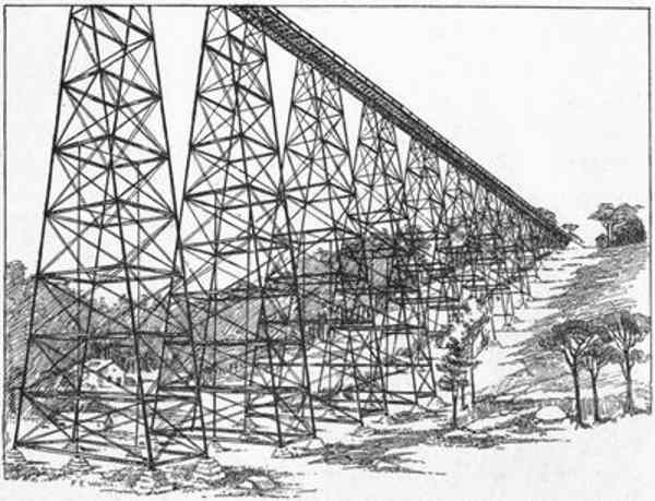
- Kinzua Viaduct
 (1088 visits) The most notable invention of latter days in bridge construction is that of the cantilever bridge, w...") View of Thomas Pope's Proposed Cantilever (1810)
View of Thomas Pope's Proposed Cantilever (1810)
The most notable invention of latter days in bridge construction is that of the cantilever bridge, which is a system devised to dispense with staging, or false works, where from the great depth, or the swift current, of the river, this would be difficult, or, as in the case of the Niagara River, impossible to make. The first design of which we have any record was that of a bridge planned by Thomas Pope, a ship carpenter of New York, who, in 1810, published a book giving his designs for an arched bridge of timber across the North River at Castle Point, of 2,400 feet span. Mr. Pope called this an arch, but his description clearly shows it to have been what we now call a cantilever. As was the fashion of the day, he indulged in a poetical description: "Like half a Rainbow rising on yon shore, While its twin partner spans the semi o'er, And makes a perfect whole that need not part Till time has furnish'd us a nobler art."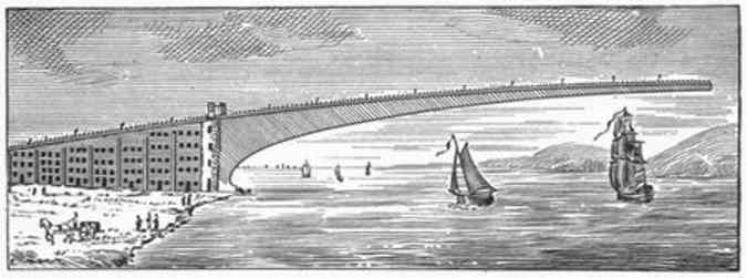
- Pope's Cantilever in Process of Erection
The most notable invention of latter days in bridge construction is that of the cantilever bridge, which is a system devised to dispense with staging, or false works, where from the great depth, or the swift current, of the river, this would be difficult, or, as in the case of the Niagara River, impossible to make. The first design of which we have any record was that of a bridge planned by Thomas Pope, a ship carpenter of New York, who, in 1810, published a book giving his designs for an arched bridge of timber across the North River at Castle Point, of 2,400 feet span. Mr. Pope called this an arch, but his description clearly shows it to have been what we now call a cantilever. As was the fashion of the day, he indulged in a poetical description: "Like half a Rainbow rising on yon shore, While its twin partner spans the semi o'er, And makes a perfect whole that need not part Till time has furnish'd us a nobler art." Note : This bridge was never built - it would be impossible in wood.  The new bridge at Poughkeepsie has three of these cantilevers, connected by two fixed spans, as show...") Erection of a Cantilever
Erection of a Cantilever
The new bridge at Poughkeepsie has three of these cantilevers, connected by two fixed spans, as shown in the illustration. The fixed spans have horizontal lower chords, and really extend beyond each pier and up the inclined portions, to where the bottom chord of the cantilever is horizontal. At these points the junctions between the spans are made, and arranged in such a way, by means of movable links, that expansion and contraction due to changes of temperature can take place. The fixed spans are 525 feet long. Their upper chord, where the tracks are placed, is 212 feet above water. These spans required stagings to build them upon. These stagings were 220 feet above water, and rested on piles, driven through 60 feet of water and 60 feet of mud, making the whole height of the temporary staging 332 feet, or within 30 feet of the height of Trinity Church steeple, in New York. The[35] time occupied in building one of these stagings and then erecting the steel-work upon it was about four months. The cantilever spans were erected without any stagings at all below, and entirely from the two overhead travelling scaffolds, shown in the engraving. These scaffolds were moved out daily from the place of beginning over the piers, until they met in the centre. The workmen hoisted up the different pieces of steel from a barge in the river below and put them into place, using suspended planks to walk upon. The time saved by this method was so great that one of these spans of 548 feet long was erected in less than four weeks, or one-seventh of the time which would have been required if stagings had been used.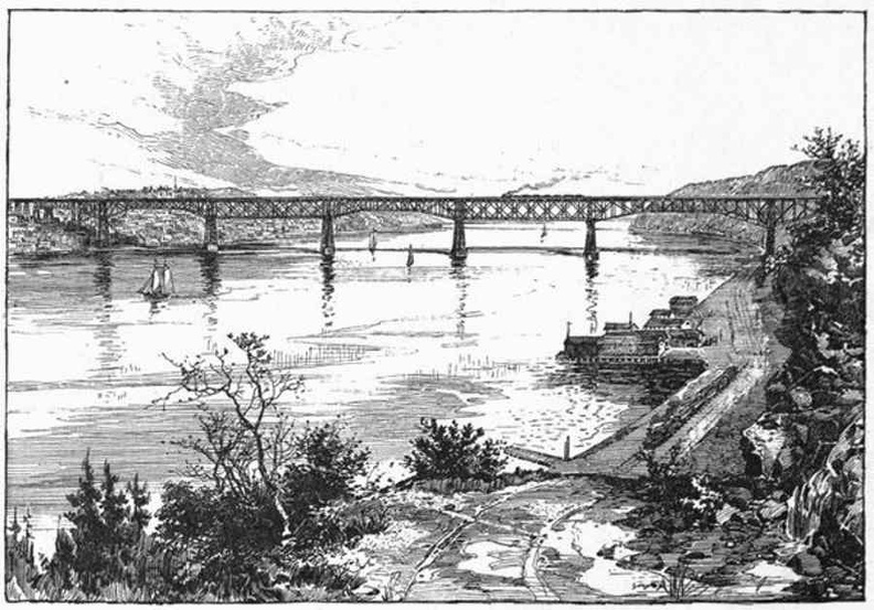
- General View of the Poughkeepsie Bridge
The new bridge at Poughkeepsie has three of these cantilevers, connected by two fixed spans, as shown in the illustration. The fixed spans have horizontal lower chords, and really extend beyond each pier and up the inclined portions, to where the bottom chord of the cantilever is horizontal. At these points the junctions between the spans are made, and arranged in such a way, by means of movable links, that expansion and contraction due to changes of temperature can take place. The fixed spans are 525 feet long. Their upper chord, where the tracks are placed, is 212 feet above water. These spans required stagings to build them upon. These stagings were 220 feet above water, and rested on piles, driven through 60 feet of water and 60 feet of mud, making the whole height of the temporary staging 332 feet, or within 30 feet of the height of Trinity Church steeple, in New York. The time occupied in building one of these stagings and then erecting the steel-work upon it was about four months. The cantilever spans were erected without any stagings at all below, and entirely from the two overhead travelling scaffolds, shown in the engraving. These scaffolds were moved out daily from the place of beginning over the piers, until they met in the centre. The workmen hoisted up the different pieces of steel from a barge in the river below and put them into place, using suspended planks to walk upon. The time saved by this method was so great that one of these spans of 548 feet long was erected in less than four weeks, or one-seventh of the time which would have been required if stagings had been used.  The Opera House, a new and handsome building, is on Euclid avenue. There are, besides, an Academy of...") Euclid Avenue, Cleveland, Ohio
Euclid Avenue, Cleveland, Ohio
The Opera House, a new and handsome building, is on Euclid avenue. There are, besides, an Academy of Music and the Globe Theatre and several minor theatres. The business portion of Euclid avenue extends from the Park to Erie street, beyond which it is lined with handsome residences, elegant cottages and superb villas, the grounds around each being more and more extensive as it approaches the country. It is one of the finest avenues in the world, and is not less than ten miles in length, embracing during its course several suburbs which a generation since were remote from the city, and are now considerably surprised to find themselves brought so near it. Euclid avenue crosses the other streets diagonally, and was evidently one of the original roads leading into the city before it attained its present dimensions. The majority of the streets are parallel with the lake front, which pursues a course from the northeast to the southwest. But Euclid avenue runs directly eastward for about three miles, to Doane's Corners, one of the historic spots in the neighborhood of Cleveland, and then turns to the northeast, following nearly parallel to the course of the lake. Prospect street runs parallel to Euclid avenue, and is only second to it in the beauty and elegance of its residences. St. Clair street is also a favorite suburban avenue, extending parallel to the lake, a little distance from it, far out into the country, and containing many handsome residences. An Old-fashioned Train of Cars") An Old-fashioned Train of Cars
An Old-fashioned Train of Cars
An Old-fashioned Train of Cars") McCormick's Reaping Machine
McCormick's Reaping Machine") The First Type of McCormick Reaper
The First Type of McCormick Reaper") The Old Way of Reaping
The Old Way of Reaping") Silhouettes of Grandfather and Grandmother
Silhouettes of Grandfather and Grandmother") Sextuple Perfecting Press
Sextuple Perfecting Press") Curved Stereotype Plate
Curved Stereotype Plate") Franklin's Printing Press
Franklin's Printing Press") The Earliest Printers at Work
The Earliest Printers at Work") A Monk Copying Manuscript Books
A Monk Copying Manuscript Books") Daniel Webster
Daniel Webster") Charles Goodyear
Charles Goodyear") Kitchen in which Goodyear made his Experiments
Kitchen in which Goodyear made his Experiments") Natives Drying Rubber
Natives Drying Rubber") Tapping a Rubber Tree
Tapping a Rubber Tree") Birthplace of Charles Goodyear
Birthplace of Charles Goodyear") Edison in his Library
Edison in his Library") Edison's First Phonograph
Edison's First Phonograph