


 Scattered mammoth and mastodon remains have been found in glacial deposits at various localities in ...") Woolly mammoth
Woolly mammoth
Scattered mammoth and mastodon remains have been found in glacial deposits at various localities in the state. Peat, which is an accumulation of partially decomposed plant materials, has been found, especially in the northern part of the state. It is marketed as an organic soil conditioner.") William, Prince of Orange
William, Prince of Orange") Wellesley College in 1886
Wellesley College in 1886 VIEW of BETHLEHEM a Moravian settlement.
I. Weld del. J. Dadley sculpt.
Published Dec. 12 1798, by...") View of Bethlehem a Moravian settlement
View of Bethlehem a Moravian settlement
VIEW of BETHLEHEM a Moravian settlement. I. Weld del. J. Dadley sculpt. Published Dec. 12 1798, by I. Stockdale, Picadilly. Bethlehem is the principal settlement, in North America, of the Moravians, or United Brethren. It is most agreeably situated on a rising ground, bounded on one side by the river Leheigh, which falls into the Delaware, and on the other by a creek, which has a very rapid current, and affords excellent seats for a great number of mills. The town is regularly laid out, and contains about eighty strong built stone dwelling houses and a large church. Three of the dwelling houses are very spacious buildings, and are appropriated respectively to the accommodation of the unmarried young men of the society, of the unmarried females, and of the widows. In these houses different manufactures are carried on, and the inmates of each are subject to a discipline approaching somewhat to that of a monastic institution. They eat together in a refectory; they sleep in dormitories; they attend morning and evening prayers in the chapel of the house; they work for a certain number of hours in the day; and they have stated intervals allotted to them for recreation. (1147 visits) The most notable invention of latter days in bridge construction is that of the cantilever bridge, w...") View of Thomas Pope's Proposed Cantilever (1810)
View of Thomas Pope's Proposed Cantilever (1810)
The most notable invention of latter days in bridge construction is that of the cantilever bridge, which is a system devised to dispense with staging, or false works, where from the great depth, or the swift current, of the river, this would be difficult, or, as in the case of the Niagara River, impossible to make. The first design of which we have any record was that of a bridge planned by Thomas Pope, a ship carpenter of New York, who, in 1810, published a book giving his designs for an arched bridge of timber across the North River at Castle Point, of 2,400 feet span. Mr. Pope called this an arch, but his description clearly shows it to have been what we now call a cantilever. As was the fashion of the day, he indulged in a poetical description: "Like half a Rainbow rising on yon shore, While its twin partner spans the semi o'er, And makes a perfect whole that need not part Till time has furnish'd us a nobler art."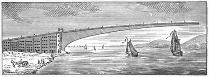
 VIEW of the Lesser FALL of NIAGARA
I.Weld del. J. Scott sculpt.
Published Dec. 22, 1798, by J. Sto...") View of the Lesser Fall of Niagara
View of the Lesser Fall of Niagara
VIEW of the Lesser FALL of NIAGARA I.Weld del. J. Scott sculpt. Published Dec. 22, 1798, by J. Stockdale Picadilly. VIEW of the HORSE-SHOE FALL of NIAGARA
I.Weld del. Neele Scupt.
Published by J. Stockdale Picadill...") View of the Horse-Shoe Fall of Niagara
View of the Horse-Shoe Fall of Niagara
VIEW of the HORSE-SHOE FALL of NIAGARA I.Weld del. Neele Scupt. Published by J. Stockdale Picadilly. View of the FALLS of Niagara
J. Scott
Published Dec.14 1798, by J. Stockdale") View of the Falls of Niagara
View of the Falls of Niagara
View of the FALLS of Niagara J. Scott Published Dec.14 1798, by J. Stockdale The water tank is seen frequently along the route of the railroads and plenty of water must be taken...") The water tank
The water tank
The water tank is seen frequently along the route of the railroads and plenty of water must be taken on and carried in the engine tender to make steam which is the power used to drive the big engines. The great drouths caused the price of corn to fluctuate but the aggregate corn yield kept on increa...") The Summer that the rain came not
The Summer that the rain came not
The great drouths caused the price of corn to fluctuate but the aggregate corn yield kept on increasing with increased acreage and usually the year following a drouth was one of superabundance of corn. Such was the year of 1895 following the drouth of 1894. The proportion of cattle per thousand population steadily increased. Meanwhile our cattle markets became centralized and were always full to overflowing. Everybody wondered where the cattle came from. The Round House is the place where the railroad engines are kept when they are not working. The engi...") The Round House
The Round House
The Round House is the place where the railroad engines are kept when they are not working. The engines are turned around on a big turn table so each can be run on the different tracks which all lead to the turn-table in the centre.") The right Honourable Ferdinand--Lord Fairfax
The right Honourable Ferdinand--Lord Fairfax") The Residence of Abraham Lincoln
The Residence of Abraham Lincoln") The Old Way of Reaping
The Old Way of Reaping The upper figure is a broadside view, the lower one a transverse section amidships. The upper portio...") The Monitor, the famous little ship that revolutionized warship design
The Monitor, the famous little ship that revolutionized warship design
The upper figure is a broadside view, the lower one a transverse section amidships. The upper portion of the hull was very like a raft, and was heavily armoured all over, as was the turret and the little pilot-box forward.") The Last Span - ready to join
The Last Span - ready to join The Hoze nozzle has been taken up to the roof of a building next the one afire and the firemen are s...") The Hoze nozzle
The Hoze nozzle
The Hoze nozzle has been taken up to the roof of a building next the one afire and the firemen are sending the water into the upper floors of the burning building. The hose nozzle is very difficult for the firemen to hold.") The flag Major Anderson carried with him from Fort Sumter
The flag Major Anderson carried with him from Fort Sumter") The First Type of McCormick Reaper
The First Type of McCormick Reaper The Fireman's dog goes to every fire, running beside the horses, barking a command to hurry. He gets...") The Fireman's dog
The Fireman's dog
The Fireman's dog goes to every fire, running beside the horses, barking a command to hurry. He gets to the fire hydrant first and sits there panting until the Firemen come up to attach the hose and turn on the water. The Fire Alarm is sounded by a big gong in the station from street alarm boxes near where the fire o...") The Fire Alarm
The Fire Alarm
The Fire Alarm is sounded by a big gong in the station from street alarm boxes near where the fire occurs. The firemen know these alarm stations so well that they seldom look for the address, but dash off quickly to the correct place.") The English Antick
The English Antick Crust (6-30 miles)
Mantle (1800 miles)
Outer core (1400 miles)
Inner core (750 miles)
The core...") The earth with a segment removed to show supposed internal zones
The earth with a segment removed to show supposed internal zones
Crust (6-30 miles) Mantle (1800 miles) Outer core (1400 miles) Inner core (750 miles) The core is the innermost zone of the earth. It is mainly iron with some nickel and cobalt. The inner core probably is solid, but the outer core may consist of the same elements in a molten form. The core is the most dense (heaviest) of the three zones.") The Earliest Printers at Work
The Earliest Printers at Work") The Dominion Astrophysical Observatory - from the south
The Dominion Astrophysical Observatory - from the south The brave fireman rescues many people who are caught in burning buildings, in this way risking his l...") The brave fireman
The brave fireman
The brave fireman rescues many people who are caught in burning buildings, in this way risking his life that others may be saved from the smoke and flames. Many people owe their lives to the bravery of the firemen. The Automobile Fire Engine can go to the fires very swiftly. Many times the saving of a few minutes ...") The Automobile Fire Engine
The Automobile Fire Engine
The Automobile Fire Engine can go to the fires very swiftly. Many times the saving of a few minutes by the firemen in reaching a fire means stopping the blaze before it becomes too great.") The Alarm
The Alarm") Tapping a Rubber Tree
Tapping a Rubber Tree") Stock Indicator or 'Ticker'
Stock Indicator or 'Ticker' On the prairies of the West the road-bed is thrown up from ditches on each side, either by men with ...") Steam Excavator
Steam Excavator
On the prairies of the West the road-bed is thrown up from ditches on each side, either by men with wheelbarrows and carts, or by means of a ditching-machine, which can move 3,000 yards of earth daily. In this case the track follows immediately after the embankment, and the men live in cars fitted up as boarding-shanties, and moved forward as fast as required. In all countries, old and new, mountainous and level, the rule should be to keep the level of track ...") Snow-sheds, Selkirk Mountains, Canadian Pacific
Snow-sheds, Selkirk Mountains, Canadian Pacific
In all countries, old and new, mountainous and level, the rule should be to keep the level of track well above the surface of the ground, in order to insure good drainage and freedom from snow-drifts. The question of avoidance of obstruction by snow is a very serious one upon the Rocky Mountain lines, and they could not be worked without the device of snow-sheds—another purely American invention. There are said to be six miles of staunchly built snow-sheds on the Canadian Pacific and sixty miles on the Central Pacific Railway. The quantity of snow falling is enormous, sometimes amounting to 250,000 cubic yards, weighing over 100,000 tons, in one slide. It is stated by the engineers of the Canadian Pacific, that the force of the air set in motion by these avalanches has mown down large trees, not struck by the snow itself. Their trunks, from one to two feet in diameter, remain, split as if struck by lightning.") Sir Thomas Orchard, Knight
Sir Thomas Orchard, Knight") Simple designs for taffeta street dresses
Simple designs for taffeta street dresses") Silhouettes of Grandfather and Grandmother
Silhouettes of Grandfather and Grandmother") Sextuple Perfecting Press
Sextuple Perfecting Press") San Salvadore
San Salvadore Although the Pilgrims were the first Europeans to establish a permanent colony in northeastern North...") Samuel de Champlain’s Map of Plymouth Harbor
Samuel de Champlain’s Map of Plymouth Harbor
Although the Pilgrims were the first Europeans to establish a permanent colony in northeastern North America, they did not come to an unknown land. As early as 1605, Samuel de Champlain had mapped Plymouth Harbor, in the course of a three-year expedition during which he explored the coast from Nova Scotia to Martha’s Vineyard. The quality of his detailed and accurate observations on the land and people appears in this map, and in his notes on the visit: “There came to us two or three canoes, which had just been fishing for cod and other fish which are found there in large numbers. These they catch with hooks made of a piece of wood, to which they attach a bone in the shape of a spear and fasten it very securely. The whole has a fang-shape, and the line attached to it is made out of the bark of a tree. They gave me one of their hooks, which I took out of curiosity. In it the bone was fastened on by hemp, like that in France, as it seemed to me, and they told me that they gathered this plant without being obliged to cultivate it, and indicated that it grew to the height of four or five feet. This canoe went back on shore to give notice to their fellow inhabitants, who caused columns of smoke to arise on our account. We saw eighteen or twenty savages, who came to the shore and began to dance. Our canoe landed in order to give them some bagatelles, at which they were greatly pleased. Some of them came to us and begged us to go to their river. We weighed anchor to do so, but were unable to enter on account of the small amount of water, it being low tide, and were accordingly obliged to anchor at the mouth. I went ashore, where I saw many others, who received us very cordially. I made also an examination of the river, but saw only an arm of water extending a short distance inland, where the land is only in part cleared. Running into this is merely a brook not deep enough for boats except at full tide. The circuit of the bay is about a league. On one side of the entrance to this bay there is a point which is almost an island, covered with wood, principally pines, and adjoins sandbanks, which are very extensive. On the other side, the land is high. There are two islets in this bay, which are not seen until one has entered, and around which it is almost entirely dry at low tide. This place is very conspicuous from the sea, for the coast is very low, excepting the cape at the entrance to the bay. We named it the Port du Cap. St. Louis...”.") Robert Devereux
Robert Devereux Coal is a combustible rock that was formed by the accumulation and partial decay of vegetation. When...") Reconstruction of coal-forming swamp
Reconstruction of coal-forming swamp
Coal is a combustible rock that was formed by the accumulation and partial decay of vegetation. When coal was forming millions of years ago, most of the state was a low coastal plain bordered on the west and southwest by a shallow sea. A large variety of plants grew in great swamps which covered this coastal plain. When the plants died, they accumulated in the swamps to form thick masses of peat that were eventually covered by shallow seas and buried beneath mud and sand. Periodically, the region was above sea level, new swamps developed, new peat deposits accumulated, and more sediments were laid down. This process occurred repeatedly until over 3,000 feet of sediments had been deposited. Then the sediments were slowly compacted and hardened so that sandstones, shales, limestones, and coals were formed.") Rail Making
Rail Making") Portuguese Mappemonde. 1490
Portuguese Mappemonde. 1490") Portrait of Columbus
Portrait of Columbus- Pope's Cantilever in Process of Erection
The most notable invention of latter days in bridge construction is that of the cantilever bridge, which is a system devised to dispense with staging, or false works, where from the great depth, or the swift current, of the river, this would be difficult, or, as in the case of the Niagara River, impossible to make. The first design of which we have any record was that of a bridge planned by Thomas Pope, a ship carpenter of New York, who, in 1810, published a book giving his designs for an arched bridge of timber across the North River at Castle Point, of 2,400 feet span. Mr. Pope called this an arch, but his description clearly shows it to have been what we now call a cantilever. As was the fashion of the day, he indulged in a poetical description: "Like half a Rainbow rising on yon shore, While its twin partner spans the semi o'er, And makes a perfect whole that need not part Till time has furnish'd us a nobler art." Note : This bridge was never built - it would be impossible in wood. ") Plaid and figured material for slender figures
Plaid and figured material for slender figures About 1820, the State of Illinois was being rapidly settled by people from the eastern states. Prior...") Pioneer Wagons
Pioneer Wagons
About 1820, the State of Illinois was being rapidly settled by people from the eastern states. Prior to this time, very few white settlements had been made in the state. These early pioneers, drawn from the population of the eastern states, were composed of almost all nationalities. They pushed their way across the mountains of Pennsylvania and Virginia in crude wagons, drawn by oxen, bringing with them their household goods and a few milk cows. Physiography is the study of the creation and gradual change of land surface forms (the landscape). ...") Physiographic provinces of Illinois
Physiographic provinces of Illinois
Physiography is the study of the creation and gradual change of land surface forms (the landscape). Thus, the land surface as we see it today in each of the physiographic provinces has had a particular history of development. Driftless Area Wisconsinan Moraines Illinoian Till Plain Mississippi River Wabash River Shawnee Hills Ohio River") Part of a Telephone Exchange
Part of a Telephone Exchange In the first place, you see three broad, concentric circles, on the outside of which the rising and...") Orientation of a house to the sun
Orientation of a house to the sun
In the first place, you see three broad, concentric circles, on the outside of which the rising and setting sun is depicted for both midsummer and midwinter day. The figures, 30°–50°, alongside of the sun represent degrees of north latitude, wherever you may happen to live, which, with the exception of most of Florida and southern Texas, cover the United States. The short arrows show the direction of the sun’s rays at sunrise and sunset. The inner circle represents your horizon, and the degrees marked upon it show the points of sunrise and sunset, north or south of the direct east and west line. These angular distances, in terms of degrees, are called amplitudes, north or south, and must not be confused with the degrees of latitude on the earth’s surface, indicated by the numbers along side of the sun, though intimately dependent upon them. The amplitude of the horizon point, where the sun rises and sets from time to time during the year, always depends upon the latitude on the earth’s surface where you happen to live, as may be seen by following with your eye the direction of the arrows of latitude through the amplitude circle. Starting from the number indicating the latitude where you live, trace the arrow until it touches the amplitude circle. You can then read the degree on it which shows how far north or south of the east and west line the sun rises or sets. We are indebted to Professor Philip Fox, of the Dearborn Astronomical Observatory at Evanston, Illinois, for determining these points. The two outer circles are sun-dials for midsummer and midwinter day at the 40th degree of north latitude; and, if you imagined them pivoted on their rising and setting points and tipped up from the south to represent the slanting path of the sun during the day, they show the direction from which the sun is shining during successive hours of the day (or night on the other side of the world). The shaded portions of these circles represent night, which for all northern latitudes is short in summer and long in winter, as the day is short in winter and long in summer. If you examine the hour spaces on the winter dial of your winter night, you will find them exactly like those on the summer dial of your summer day. So also your winter day hours are spaced like your summer night hours. South of the equator, people have precisely the same experiences only in the reverse order. New Zealanders, we fancy, wear straw hats in January and fur caps in July. If you liked summer well enough and cared to move, you could live in a perpetual summer on our little globe. It is probable, however, that, like most people, you rather prefer the change of seasons, in spite of occasional extremes. ... a sketch of a pair of pulley-weights recently made, designed by Dr. Sargent, which are excellent...") Noiseless Pulley-weights
Noiseless Pulley-weights
... a sketch of a pair of pulley-weights recently made, designed by Dr. Sargent, which are excellent. Their merits will be seen at a glance. Instead of the weights swaying sideways and banging against the boxes, as they are liable to do in the ordinary old-fashioned pulley-weight boxes, they travel in boxes, A A, between the rods B B. A rubber bed also prevents the weight from making a noise as it strikes the floor, while another capital feature is the arrangement of boxes, in which you may graduate the weight desired by adding little plates of a pound each, instead of the unchanging weight of the old plan.") Ninon de l'Enclos
Ninon de l'Enclos Nellie Pitezel") Nellie Pitezel
Nellie Pitezel
Nellie Pitezel") Natives Drying Rubber
Natives Drying Rubber Nannie Williams") Nannie Williams
Nannie Williams
Nannie Williams") Mrs. William Clark
Mrs. William Clark Mrs Pitezel") Mrs Pitezel
Mrs Pitezel
Mrs Pitezel") Mr. Alderman Abell and Richard Kilvert, the two maine Projectors for Wine, 1641
Mr. Alderman Abell and Richard Kilvert, the two maine Projectors for Wine, 1641") McCormick's Reaping Machine
McCormick's Reaping Machine") Mayor Rip Van Dam
Mayor Rip Van Dam After the railway line has been finally located, the next duty of the engineers is to prepare the wo...") Making an Embankment
Making an Embankment
After the railway line has been finally located, the next duty of the engineers is to prepare the work for letting. Land-plans are made, from which the right of way is secured. From the sections, the quantities are taken out. Plans of bridges and culverts are made; and a careful specification of all the works on the line is drawn up. The works are then let, either to one large contractor or to several smaller ones, and the labor of construction begins. The duties of the engineers are to stake out the work for the contractors, make monthly returns of its progress, and see that it is well done and according to the specifications and contract. The line is divided into sections, and an engineer, with his assistants, is placed in charge of each. Where the works are heavy, the contractors build shanties for their men and teams near the heavy cuttings or embankments. It is the custom to take out heavy cuttings by means of the machine called a steam shovel, which will dig as many yards in a day as 500 men.